Illiniza Norte and Illiniza Sur make up the peaks known as the Illinizas. A long long time ago, the son of a local leader, and the daughter of a rival leader fell in love. The boys’ father was not happy about this, and he hired a wizard to take care of the situation. The wizard took the girl and using powerful magic, he turned her to stone. He turned her into Illiniza Norte. Now the boy was devastated. He did not know what
 happened to his love. He abandoned his father and set out looking for her. For years he traveled up and down the paramo, searching and telling people his story. One day he came across a wizard, the same wizard who had turned his love into Illiniza Norte. With much pleading, the wizard finally agreed to give the boy his wish. Using powerful magic, he turned him into Illiniza Sur, so that the two lovers could always be together.
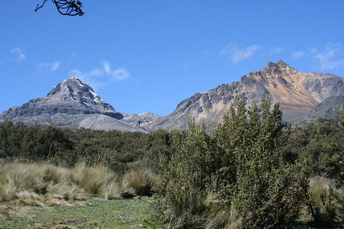
Like the story says, the Illinizas are two mountains that have a real aura of magic about them. Illiniza Norte is gentile and beautiful. Her colors of red, yellow, orange, white, and black constantly changing and emerging with the light. Illiniza Sur is more hidden, and fiercer, but he sparkles and shines amazingly. Illiniza Sur is considered one of the most difficult and technical climbs in Ecuador.
After finally escaping the Quito vortex, we headed south to the little town of Chaupi which sits just under the Illinizas. Chaupi has a nice climber’s hostel, hostal Llovizna, with hot water, several rooms, good food, ping-pong, and a pool table! (even if the cues don’t have felt tips on them). We unloaded our stuff, and got ready for the approach tomorrow morning. Three British climbers soon arrived at the hostel that had just come down from Illiniza Sur. We drank beer and played pool while they told us about the climb. It was great to get such current information about snow and ice conditions and route finding difficulties. That night, we took a walk around the small central square of Chaupi and saw our new friends in a restaurant/bar/pool room. Rod went to get a glass of the local liquor, aguardiente, but he accidentally purchased a whole bottle it, peach flavored (his Spanish has gotten much better since). So, everyone ended up getting a little more shnockerd than planned, including the waiter, who we kept serving shots to each time he came to the table.
Next morning we drove up the rutted out dirt road to the Illiniza trail head, then plodded our way up the long moraine ridge to the refugio nestled just below the col between the two mountains.
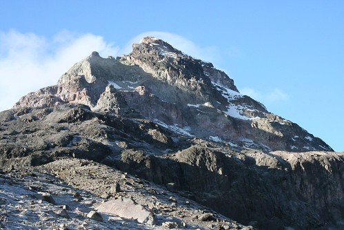
 This refugio was smaller, and dirtier than the one on Cotopaxi, but did have two gas stoves and a gas lantern. The peak of Illiniza sur was covered with clouds as we hiked up to the col between the mountains and did a little route pre-inspection. Illiniza norte was not clouded over, however, and we were awed by the colors of the peak, its ruggedness, and the beautiful green lake at its base. I practiced some yoga and aikido movements in the meadow next to the refuge before dinner, then again to bed early with a wake up time set for 2:15am.
Up and Out and Up. The route finding in the dark for the normal route up Illiniza sur was the most difficult part. We headed up to the col, then up the moraine. We went over the moraine and down into the obvious drainage, then followed that to drop down onto the glacier. We got a bit lost here because we were hesitant to keep following the glacier down. It is quite a ways. We were looking for a ramp up the rock cliff/ridge too early. We found on the return that you can stay up on the moraine (don’t follow the cairns into the drainage between the mountain and the moraine) and follow it’s ridge down to where you can just cross the glacier to the ramp up the rock cliff/ridge. However, if you keep walking down the glacier between the moraine and the rock cliff/ridge, you will get to the ramp up and onto the cliff/ridge, and maybe this is easier travel. Once up the ramp, we moved around the corner and up a short class 4 scramble to gain the ridge. Then it was just a walk strait up to the snowfield.
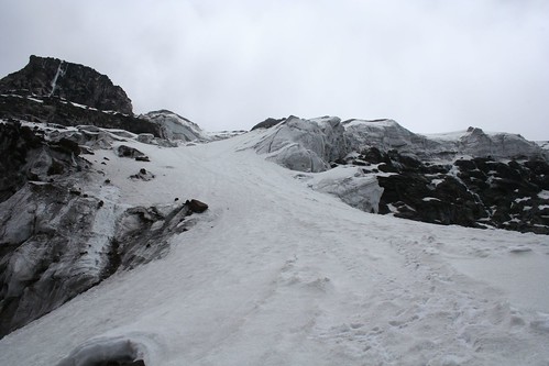
 We approached the snow field from high up on the climbers left side because this avoided some ice fields at the base of this glacier. Once on the snow, the route was obvious.
  It begins with a long steepish (~45-50 degree) pitch that has some crevasses at the top where the slope shallows with thin (almost alarming) snow bridges. Then the route turns slightly climbers right until you reach the crux of the climb, 100m of steep snow/ice above a small crevasse. We climbed this pitch traditionally, setting pro and belaying from an anchor at the top. The belay at the top of it was really cool! It was sitting on a narrow ridge of snow that dropped on the other side into one of the biggest, deepest crevasse I have ever seen. After this, the route moves to the climbers left and up the snowfield toward the large rocky outcrop near the summit. From the base of the rocky outcrop, we could see the summit to the right. What a crazy funky summit! It is just a massive ice block, one with the strangest textures and formations on it. A hulking, bulbous, icicle, sasquatch hiding, chunk of ice sitting on the top of a mountain. Crazy!
  We followed the ice/snow ridge up and around climbers’ right to the summit (5245 m, 17,308 feet).
No comments:
Post a Comment