Tlalocapetl is the mountain of the Aztec water and fertility god, Tlaloc. Tlaloc is the bringer of water. He can bring good rains ensuring a good harvest, or drought, decimating floods, and lightning storms. Yearly, the Aztec made pilgrimages to the top the the mountain to appease Tlaloc by sacrificing a baby or small child. It is said that the more the baby cried, it’s tears drops of water to Tlaloc, the better the rains that year.
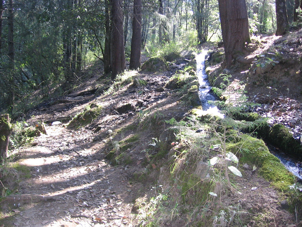
The mountain itself has the character of Tlaloc. While hiking up, it could be very kind and nurturing at times, and at times quite forceful and severe. Walking up along the aqueduct was very pleasant.
The mountain itself has the character of Tlaloc. While hiking up, it could be very kind and nurturing at times, and at times quite forceful and severe. Walking up along the aqueduct was very pleasant.

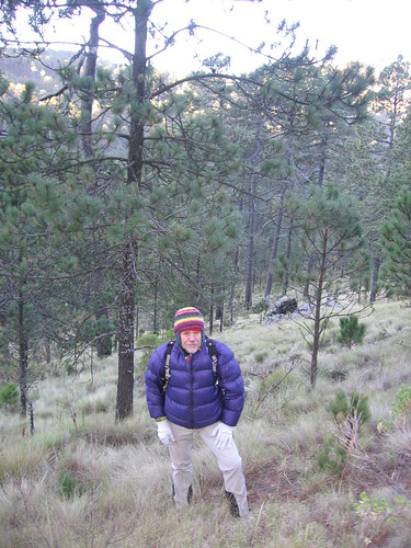
The sound of the water flow, the beautiful trail. We walked from grasslands scattered with oaks, through a mixed forest with a few trees I recognized – madrone, oak, fir, pine. With wildflowers and green mosses. Then into the coniferous forest that continued to ~13,000 ft. Beautiful big pines and firs widely spaced with a bunch grass understory. The trail was steep and demanding. At one point the trail disappeared and the only way to continue was to balance on the 3 inch-wide side of the aqueduct for about 100 m. The hillside dropped off to the right for a very exposed tight-wire act along the aqueduct.
After about 4 hours of toil, we reconnected with the road! And were blasted in the face with dust as a logging truck teetered past. It was kind of funny, i guess we could have driven up all this?!
We camped in a lush meadow (~12,500 ft) where several natural springs bubbled up. The night was very cold, and i was sure i saw shadows of Aztec ghosts between the trees and heard cries and screams of children being sacrificed in the blowing wind. Creepy.

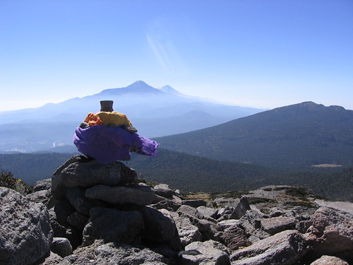
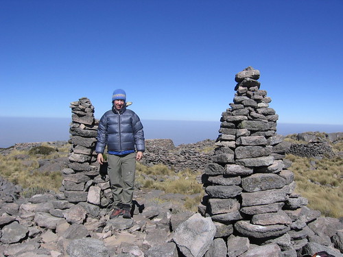
The next morning we climbed along a ridge overlooking a beautiful rock walled canyon, then into the canyon, and then a summit scramble directly up the south face. At the summit are the ruins of an Aztec temple. Two long, parallel mounds of rock line the three leveled walkway to the summit square. Inside this large square, bordered by rock walls, are several smaller mounds of rock... these are interior rooms or altars? From the summit we had a wonderful view of the two nearby volcanoes (Izta and Popo), and of the truly dumbfounding smog layer over the Mexico city valley.

We made an offering of water to Tlaloc, and after spending about .5 hr on the summit, we headed down, picked up our gear at the meadow, and retraced our steps along the aqueduct back to San Pablo. We had asked the taxi driver to be there to pick us up at 5 o'clock, and made it back at 5:07! Fehew! We quickly grabbed a Negro Modela and sipped it while rubbing our hurting feet on the bumpy ride back to Texcoco.
Tlalocapetl route description:
We hired a taxi to drive us from the town of Texcoco to the little village of San Pablo. I highly recommend either taking the bus or a taxi to San Pablo, because it would be very hard to find the town and where the approach starts on your own. From where the last bus stop is in San Pablo (where the bus turns around), continue on foot straight onto a dirt road that dips immediately through a small valley, and switches back steeply up to the left. Then continue up this road, generally staying to the left, until you reach an abandoned hut and a small aqueduct (that has running water in it). Follow this aqueduct (via road and trail) for ~ 7 miles (~3,300 feet vertical), until it disappears into the ground (buried pipe) at the edge of a meadow (at 12,500 ft). The meadow has many natural springs, and most prominently, a big blue sign discussing the aqueduct project. This should take 4-6 hours. We camped here in this meadow. (There are roads up to this meadow, so if you Spanish is good enough, you may be able to find someone in San Pablo who will drive you up to there – But the hike is very nice)
From the meadow, looking north, is a prominent rocky peak. The summit of Tlaloc is not visible, and is hidden by the slope to the north/northeast. We approached the summit by hiking up the small valley directly to the climbers right of the visible rocky peak. This becomes more of a canyon, as the cliffs to the left continue, and the slope to the right steepens. Follow this canyon/valley to the top, then turn right for a bushwhack scramble up to the summit from the south/southwest. This should take from 2-4 hours.
After about 4 hours of toil, we reconnected with the road! And were blasted in the face with dust as a logging truck teetered past. It was kind of funny, i guess we could have driven up all this?!
We camped in a lush meadow (~12,500 ft) where several natural springs bubbled up. The night was very cold, and i was sure i saw shadows of Aztec ghosts between the trees and heard cries and screams of children being sacrificed in the blowing wind. Creepy.
The next morning we climbed along a ridge overlooking a beautiful rock walled canyon, then into the canyon, and then a summit scramble directly up the south face. At the summit are the ruins of an Aztec temple. Two long, parallel mounds of rock line the three leveled walkway to the summit square. Inside this large square, bordered by rock walls, are several smaller mounds of rock... these are interior rooms or altars? From the summit we had a wonderful view of the two nearby volcanoes (Izta and Popo), and of the truly dumbfounding smog layer over the Mexico city valley.
We made an offering of water to Tlaloc, and after spending about .5 hr on the summit, we headed down, picked up our gear at the meadow, and retraced our steps along the aqueduct back to San Pablo. We had asked the taxi driver to be there to pick us up at 5 o'clock, and made it back at 5:07! Fehew! We quickly grabbed a Negro Modela and sipped it while rubbing our hurting feet on the bumpy ride back to Texcoco.
Tlalocapetl route description:
We hired a taxi to drive us from the town of Texcoco to the little village of San Pablo. I highly recommend either taking the bus or a taxi to San Pablo, because it would be very hard to find the town and where the approach starts on your own. From where the last bus stop is in San Pablo (where the bus turns around), continue on foot straight onto a dirt road that dips immediately through a small valley, and switches back steeply up to the left. Then continue up this road, generally staying to the left, until you reach an abandoned hut and a small aqueduct (that has running water in it). Follow this aqueduct (via road and trail) for ~ 7 miles (~3,300 feet vertical), until it disappears into the ground (buried pipe) at the edge of a meadow (at 12,500 ft). The meadow has many natural springs, and most prominently, a big blue sign discussing the aqueduct project. This should take 4-6 hours. We camped here in this meadow. (There are roads up to this meadow, so if you Spanish is good enough, you may be able to find someone in San Pablo who will drive you up to there – But the hike is very nice)
From the meadow, looking north, is a prominent rocky peak. The summit of Tlaloc is not visible, and is hidden by the slope to the north/northeast. We approached the summit by hiking up the small valley directly to the climbers right of the visible rocky peak. This becomes more of a canyon, as the cliffs to the left continue, and the slope to the right steepens. Follow this canyon/valley to the top, then turn right for a bushwhack scramble up to the summit from the south/southwest. This should take from 2-4 hours.

No comments:
Post a Comment