Quimsa Cruz: 3/17-19/2007
... coming soon ...
Saturday, March 17, 2007


Tuesday, March 13, 2007
Mt Sajama
Sajama: 3/13-15/2007
 Still in the rainy season (climbing snowy mountains highly improbable), we drove west to the Sajama National Park on the border of Bolivia and Chile. Sajama mountain is the tallest peak in Bolivia and stands alone, majestically towering over the high, severe altiplano. Climbing Sajama is closed until April. As we entered the park, we saw a large flock of pink flamingos wading and napping in a shallow lake. The wild life in the national park is protected, unlike most of Bolivia... maybe we will get to see some cool animals here?! Pink flamingos at 14,000 feet is a good start.
We drove into the town of Sajama, the central point of civilization in the park. We asked for directions to the geysers; the park is full of points of volcanic activity. We set off, excited to see some boiling mud pits and shooting geysers. The directions were wrong. We drove well out of town and well past the road to the geysers. Instead, we drove to the parking area for hot springs in the area. As we grabbed out bathing suits and got ready for the walk to the springs, the skys darkened and it started to hail. Not thinking too much of it, we also grabbed out ponchos and set off walking toward, what we thought, was the general direction of the hot springs.
We followed an obvious path to a river and could not see a way across, let alone a continuing path on the other side. We walked up the river and eventually found a way to jump across. We could see a steaming little creak burrowed deep into the grassy plain and when we felt its water, it was warm. Think this must lead to the hotspring, we followed the creak. Soon we encountered branching creaks in all directions and all steaming hot water. The hail was pounding down onto us, and covering the misty ground in a plaster of white pellets. Each time we saw a big vapor cloud, we thought it must be the pool. But when we got there, it was just a shallow, narrow ditch with hot water flowing through. This can’t be it? Maybe you could lay down in it and get mostly wet… where is a pool?!
Off in the distance to out left was a building. We decided to walk toward it in hopes of asking someone where to go. At the building was a large, wide pool! The spring! In a roofless room, with hail pounding down on us, we shiveringly changed into out bathing suits while using our ponchos to deflect the stinging onslaught from the sky. Despite the numbing barefoot walk to the pool, we slipped into the hot water and felt as warm and relaxed as marmots snuggling up in their winter den. The hail eventually stopped and we walked back, wet, warm, and comfortable.
We spent the night in the town of Sajama, and woke in the morning to an amazing clear-sky view of Sajama and the other mighty volcanoes to the west. This time we got good directions to the geysers, and drove up the valley between Mt. Pomerape and the smaller mountain to its north, in search. They were beautiful, but not the spouting rockets we had been lead to believe. Unfortunately, no bubbling mud pits, but happily many Technicolor bubbling water pits! After inhaling sulfur fumes for a while, we continued up the valley toward the nice looking smaller mountain to Pomerapes’ north. On the way, we spotted an Andean Fox sneaking its way through the grasses. Cool!!

At the end of the valley, we hiked up to a waterfall for lunch, then continued to a sheppard’s hut next to a small Inca ruins. We decided to climb the small snowy peak watching over this little ruins and valley. We walked back to the car to get out stuff and make camp. When we got there, the afternoon hail began again. We sat in the car for 3 hours waiting out the storm. Listening to homer’s The Iliad on the ipod, we snacked and watched the pounding hail and rain hit the windows. During a short break in the storm, we ran out an pitched our tent; then at another break we cooked and ate dinner.
We set our alarms for an early start on the mountain, and went to sleep. Next we knew, it was getting light outside… what time is it? Oh no! We slep through our alarms… it is too late to start this climb! We felt foolish and frustrated. Watched over by a keen eyed sage condor, we took a short hike to a cave then drove out toward the town. On the way, we came across an ostrich (!) crossing the road… why did the ostrich cross the road?
Because I found blood in my poop that morning, we decided to leave the park and head back to La Paz to find a doctor. (Don’t worry, it turned out not to be a big deal… just a result of the antibiotics I took to deal with the awful bug I got in La Paz)
 Still in the rainy season (climbing snowy mountains highly improbable), we drove west to the Sajama National Park on the border of Bolivia and Chile. Sajama mountain is the tallest peak in Bolivia and stands alone, majestically towering over the high, severe altiplano. Climbing Sajama is closed until April. As we entered the park, we saw a large flock of pink flamingos wading and napping in a shallow lake. The wild life in the national park is protected, unlike most of Bolivia... maybe we will get to see some cool animals here?! Pink flamingos at 14,000 feet is a good start.
We drove into the town of Sajama, the central point of civilization in the park. We asked for directions to the geysers; the park is full of points of volcanic activity. We set off, excited to see some boiling mud pits and shooting geysers. The directions were wrong. We drove well out of town and well past the road to the geysers. Instead, we drove to the parking area for hot springs in the area. As we grabbed out bathing suits and got ready for the walk to the springs, the skys darkened and it started to hail. Not thinking too much of it, we also grabbed out ponchos and set off walking toward, what we thought, was the general direction of the hot springs.
We followed an obvious path to a river and could not see a way across, let alone a continuing path on the other side. We walked up the river and eventually found a way to jump across. We could see a steaming little creak burrowed deep into the grassy plain and when we felt its water, it was warm. Think this must lead to the hotspring, we followed the creak. Soon we encountered branching creaks in all directions and all steaming hot water. The hail was pounding down onto us, and covering the misty ground in a plaster of white pellets. Each time we saw a big vapor cloud, we thought it must be the pool. But when we got there, it was just a shallow, narrow ditch with hot water flowing through. This can’t be it? Maybe you could lay down in it and get mostly wet… where is a pool?!
Off in the distance to out left was a building. We decided to walk toward it in hopes of asking someone where to go. At the building was a large, wide pool! The spring! In a roofless room, with hail pounding down on us, we shiveringly changed into out bathing suits while using our ponchos to deflect the stinging onslaught from the sky. Despite the numbing barefoot walk to the pool, we slipped into the hot water and felt as warm and relaxed as marmots snuggling up in their winter den. The hail eventually stopped and we walked back, wet, warm, and comfortable.
We spent the night in the town of Sajama, and woke in the morning to an amazing clear-sky view of Sajama and the other mighty volcanoes to the west. This time we got good directions to the geysers, and drove up the valley between Mt. Pomerape and the smaller mountain to its north, in search. They were beautiful, but not the spouting rockets we had been lead to believe. Unfortunately, no bubbling mud pits, but happily many Technicolor bubbling water pits!
 After inhaling sulfur fumes for a while, we continued up the valley toward the nice looking smaller mountain to Pomerapes’ north. On the way, we spotted an Andean Fox sneaking its way through the grasses. Cool!!

At the end of the valley, we hiked up to a waterfall for lunch, then continued to a sheppard’s hut next to a small Inca ruins. We decided to climb the small snowy peak watching over this little ruins and valley. We walked back to the car to get out stuff and make camp.
 When we got there, the afternoon hail began again. We sat in the car for 3 hours waiting out the storm. Listening to homer’s The Iliad on the ipod, we snacked and watched the pounding hail and rain hit the windows. During a short break in the storm, we ran out an pitched our tent; then at another break we cooked and ate dinner.
We set our alarms for an early start on the mountain, and went to sleep. Next we knew, it was getting light outside… what time is it? Oh no! We slep through our alarms… it is too late to start this climb! We felt foolish and frustrated. Watched over by a keen eyed sage condor, we took a short hike to a cave then drove out toward the town. On the way, we came across an ostrich (!) crossing the road… why did the ostrich cross the road?

Because I found blood in my poop that morning, we decided to leave the park and head back to La Paz to find a doctor. (Don’t worry, it turned out not to be a big deal… just a result of the antibiotics I took to deal with the awful bug I got in La Paz)
Sunday, March 11, 2007
Curahuara de Carangas
Curahuara de Carangas: 3/2-3,12-13/2007
After the nasty, barf’y, diarrhea’y spell in La Paz, we headed out in our rented 4-runner to do some rock climbing at Curahuara de Carangas. The drive there is through a beautiful, Utah-ish landscape. We asked the commander at the military base in the nearby town where the rock climbing is. As it turns out the military have a mountaineer division, and they train here (how to climb, rope work, etc). When we get to the climbing area, we found it bustling with camo-clad soldiers getting ready for a graduation ceremony, that will take place tomorrow, under the climbing area. A little uneasy about our climbing prospects, we pitch camp and enjoy watching a thunder and lightning show approach us as we ate dinner. The storm gets a little too close for comfort… we moved the car further away from the tent.
The next morning we woke up to a military marching band playing about 100 m from our camp. They were loudly processing up to their graduation ceremony area, and playing for the civilians that were in attendance. After breakfast, we walked to the base of the climbs, watched the military demonstrations for a while, and decided that we didn’t want to be climbing right in the middle of it all. Our luck… this ceremony happens once a year and we chose this exact date to climb here!! We went off to an area to the side and set up ropes to practice crevasse rescue and glacier travel skills. We stayed until the afternoon, then decided to come back to climb another day.
When we came back to Curahuara de Carangas (after finding Tunupa), we had a much better (and quieter) climbing experience. This little cliff band is beautiful, and the surrounding area is filled with amazing rock features and wildlife. During dusk and dawn the quiet peace is consistently broken by the loud squawks of the three nesting Condors in the cliff band. And, as we walked along the top of the cliffs in the afternoon, we were surprised to find that we were being studied for a while by a wise silent owl.
The climbing here is excellent, and we got a good morning in before the skies darkened and we were barraged by hail. We thought we would stick it out, that it would be a short inconvenience… we ate some lunch, opened a beer… it didn’t stop. We pulled our gear and took a hike in the rain/hail for the afternoon. We left the next morning.
After the nasty, barf’y, diarrhea’y spell in La Paz, we headed out in our rented 4-runner to do some rock climbing at Curahuara de Carangas. The drive there is through a beautiful, Utah-ish landscape.
 We asked the commander at the military base in the nearby town where the rock climbing is. As it turns out the military have a mountaineer division, and they train here (how to climb, rope work, etc). When we get to the climbing area, we found it bustling with camo-clad soldiers getting ready for a graduation ceremony, that will take place tomorrow, under the climbing area. A little uneasy about our climbing prospects, we pitch camp and enjoy watching a thunder and lightning show approach us as we ate dinner. The storm gets a little too close for comfort… we moved the car further away from the tent.
The next morning we woke up to a military marching band playing about 100 m from our camp. They were loudly processing up to their graduation ceremony area, and playing for the civilians that were in attendance.
After breakfast, we walked to the base of the climbs, watched the military demonstrations for a while, and decided that we didn’t want to be climbing right in the middle of it all. Our luck… this ceremony happens once a year and we chose this exact date to climb here!! We went off to an area to the side and set up ropes to practice crevasse rescue and glacier travel skills. We stayed until the afternoon, then decided to come back to climb another day.When we came back to Curahuara de Carangas (after finding Tunupa), we had a much better (and quieter) climbing experience. This little cliff band is beautiful, and the surrounding area is filled with amazing rock features and wildlife.
During dusk and dawn the quiet peace is consistently broken by the loud squawks of the three nesting Condors in the cliff band. And, as we walked along the top of the cliffs in the afternoon, we were surprised to find that we were being studied for a while by a wise silent owl.The climbing here is excellent, and we got a good morning in before the skies darkened and we were barraged by hail. We thought we would stick it out, that it would be a short inconvenience… we ate some lunch, opened a beer… it didn’t stop. We pulled our gear and took a hike in the rain/hail for the afternoon. We left the next morning.
Sunday, March 4, 2007
Monday, February 26, 2007
Saturday, February 24, 2007
Mt Cayambe
Mt Cayambe: 2/23-25/2007
Located exactly on the equator, Cayambe is place of paradox and wonder. It is the highest spot on the equator in the world. It is so strange to see such superb glaciers at a place conventionally thought tropical. This is an icy, harsh, strong, and beautiful mountain... no tropical paradise!
... although, it is a tropical paradise ...
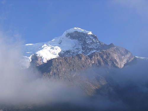
Of all the mountains in Ecuador we have visited, to me, Cayambe is the most beautiful and magnificent. On it's north side the area is a designated an Ecological Reserve. The one road through the area winds up through high tropical forest, then into grasslands scattered with odd funky jungle plants, then stops at a view of these equatorial glaciers. We drove up to the end of the road, to some antennae on a hill, then walked further up the valley to view the north face climbing route (this photo is a view of the north face).

We decided not to climb the north route, and go tomorrow to climb the more popular southern route. But, this north side is so special, the place is awe inspiring, and the route looks really exciting. This is one of the spots we are visiting on this trip that I most certainly want to come back to and spend more time. I don't think Cayambe should be an Ecological Reserve. I think the Ecuador government is making a big mistake not making this a National Park.
The next day we drove up the rough rocky road to the refuge at the base of the south face. The wind was blowing hard and cold as we unloaded our gear from the car and set up our beds in the refuge. After a warm snack, we walked up the rocky first section of the route to the head of the glacier. It was blowing so hard it knocked me over once, and the spits of rain covered the rocks with a slippery layer of clear ice.

Back at the refuge, we ate some dinner, talked to another group of climbers there about the route and climbing strategies, then got into bed before sunset. At midnight the whole refuge was up and nosily getting ready to climb... sorting gear, eating breakfast, filling water bottles with hot water. We could hear the wind howling and gusting outside. When we went out, it was much worse than we thought. At the refuge (i.e low elevation) the wind was gusting to 60 mph, and sending missiles of frozen rain into our faces. What was happening up high?
After standing outside for about 15 minutes, discussing, evaluating, arguing, freezing, we decided not to climb. The weather was just too bad. Part of the other climbing group decided to go for it. We got back into our sleeping bags feeling a little embarrassed, a little inadequate, a little pathetic, and wondering if the bad weather would let up, and if the other group would be at the summit after a great climb while we sat eating breakfast down in the refuge.
At about 3:00 am, we were awoken by the loud boots and voices of the other group returning to the refuge. They said that the climb was horrendous. They made it to the head of the glacier, but the wind was so strong, it was blowing people over, and on slick exposed ice, that is not a situation to be in. And it was just getting worse. On the walk back to the refuge the icy rocky trail was so dangerous with the wind, they had to set up rappels. Needless to say, we guiltily felt great that we had made the right decision not to climb.
Located exactly on the equator, Cayambe is place of paradox and wonder. It is the highest spot on the equator in the world. It is so strange to see such superb glaciers at a place conventionally thought tropical. This is an icy, harsh, strong, and beautiful mountain... no tropical paradise!
... although, it is a tropical paradise ...
Of all the mountains in Ecuador we have visited, to me, Cayambe is the most beautiful and magnificent. On it's north side the area is a designated an Ecological Reserve. The one road through the area winds up through high tropical forest, then into grasslands scattered with odd funky jungle plants, then stops at a view of these equatorial glaciers. We drove up to the end of the road, to some antennae on a hill, then walked further up the valley to view the north face climbing route (this photo is a view of the north face).
We decided not to climb the north route, and go tomorrow to climb the more popular southern route. But, this north side is so special, the place is awe inspiring, and the route looks really exciting. This is one of the spots we are visiting on this trip that I most certainly want to come back to and spend more time. I don't think Cayambe should be an Ecological Reserve. I think the Ecuador government is making a big mistake not making this a National Park.
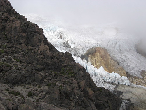
The next day we drove up the rough rocky road to the refuge at the base of the south face. The wind was blowing hard and cold as we unloaded our gear from the car and set up our beds in the refuge. After a warm snack, we walked up the rocky first section of the route to the head of the glacier. It was blowing so hard it knocked me over once, and the spits of rain covered the rocks with a slippery layer of clear ice.
Back at the refuge, we ate some dinner, talked to another group of climbers there about the route and climbing strategies, then got into bed before sunset. At midnight the whole refuge was up and nosily getting ready to climb... sorting gear, eating breakfast, filling water bottles with hot water. We could hear the wind howling and gusting outside. When we went out, it was much worse than we thought. At the refuge (i.e low elevation) the wind was gusting to 60 mph, and sending missiles of frozen rain into our faces. What was happening up high?
After standing outside for about 15 minutes, discussing, evaluating, arguing, freezing, we decided not to climb. The weather was just too bad. Part of the other climbing group decided to go for it. We got back into our sleeping bags feeling a little embarrassed, a little inadequate, a little pathetic, and wondering if the bad weather would let up, and if the other group would be at the summit after a great climb while we sat eating breakfast down in the refuge.
At about 3:00 am, we were awoken by the loud boots and voices of the other group returning to the refuge. They said that the climb was horrendous. They made it to the head of the glacier, but the wind was so strong, it was blowing people over, and on slick exposed ice, that is not a situation to be in. And it was just getting worse. On the walk back to the refuge the icy rocky trail was so dangerous with the wind, they had to set up rappels. Needless to say, we guiltily felt great that we had made the right decision not to climb.
Tuesday, February 20, 2007
Subscribe to:
Posts (Atom)